IJCRR - 7(19), October, 2015
Pages: 31-36
Date of Publication: 10-Oct-2015
Print Article
Download XML Download PDF
NODAL NETWORK ANALYSIS TO ASSESS THE TRANSPORT EFFICIENCY THROUGH HIGHWAYS IN THE STATE OF WEST BENGAL
Author: Eshita Boral, Sukla Bhaduri
Category: Healthcare
Abstract:Transportation network development is considered to be one of the keys to modernization and development. An efficient road network is inevitable for meeting the needs of a sound transportation system in the country. This paper seeks to derive the transport efficiency of selected nodes within West Bengal through the existing highway system in the state. The study of network includes an analysis of intersections or nodes with the help of connectivity and centrality indices. Results derived indicates that
with increase in number of highways within the state not only has the degree of connectivity between nodes enhanced but also has the accessibility, since nodes are becoming more and more centrally located in the system with the development of the integrated network of highways over the Road Plans.
Keywords: Network analysis, Transport efficiency, Direct connectivity, Matrix, Degree of centrality
Full Text:
INTRODUCTION
Transportation is a measure of relations between areas and therefore an important indicator of development of a region. Highway system induces changes in relative location of urban centers (Garrison, 1974). It has been observed that within the state of West Bengal intersections between highways or nodes lying along highways are the major centers of development. This can be related to the fact that highways support maximum traffic movement within the state and beyond for both passenger and freight. There has been a substantial shift in the mode of transportation from railways towards the road sector accounting to a rail-road ratio of 40:60 since 2005-06 (Directorate of Industries, 2008). Thus highways are increasingly gaining importance and their connectivity and accessibility within a state and with its neighbouring states are being directly related with the development of the area it passes through. The state of West Bengal has been of great significance in the eastern part of the country since the British rule. With Kolkata as the state capital as well as a port city, transport linkages with it were of importance for the northern and eastern part of the country. In this context it is necessary to analyze the efficiency of the transport network of the state in terms of highways, which is the most important category road in the country.
Objectives
This research work attempts to determine the competence of the highway network in the state through nodal perspectives.
The objectives of the paper therefore are –
i) To derive the direct connectivity linkages of the intersections within the highway system with one another.
ii) To determine the degree of centrality of the selected nodes.
iii) To analyze the transport efficiency of the state of West Bengal on the basis of its highway network.
Study Area
The research work is undertaken in the state of West Bengal, situated in the eastern part of India. The state, covering an area of 88752 sq. km and consisting of a total population of about 90,310,785, includes one of the major metropolis in the country, Kolkata. 17 National Highways and 19 State Highways run through the nineteen districts of the state.
MATERIALS AND METHODS
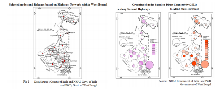
The materials for the study has been collected from Government of India organizations i.e. National Highway Authority of India (NHAI) and Census of India and Government of West Bengal organizations namely Public Works Department (PWD). The analysis of overall development of highway network in the state of West Bengal involves selection of certain nodes. Accordingly twenty six nodes are selected on basis of it being a District Head quarter and town greater in population than the District Head quarter, directly connected by either a National Highway or a State Highway. The regional highway network determines connection between these nodes. For the purpose of the study this system of highways has been developed into a topological map, where the line patterns or networks are described in terms of their topological characteristics, which do not rely so much upon distances and directions but rather upon contiguity, relative locations and systematization of lines and junctions (Saxena, 2010). Fig 1 depicts topological transformation of actual routes. It is necessary to mention that topological properties in a transportation system determine the efficiency of the transportation network if the system is idealized as a set of points (vertices) connected by a set of line segments (edges). Efficiency of transport network has been assessed through –
i) Degree of Direct Connectivity
ii) Degree of Centrality
DERIVATION OF TRANSPORT EFFICIENCY
The total length of the National and State Highways in West Bengal has been increasing over the years and so has their connectivity. More and more cities and towns have been linked with highways directly over the plan periods in the state. An analysis of these grouping of nodes makes it apparent that the linkage of nodes has been characteristic over the years. After independence roads were recognized as National Highways and there emerged five National Highways in West Bengal. State Highways were not yet recognized, however, few of the existent state roads served as excellent feeder to National Highways.
DEGREE OF DIRECT CONNECTIVITY
Direct Connectivity measures the number of direct connection of each node in terms of the linkage it establishes with any other nodes through the highways. For this purpose a matrix has been prepared where horizontal rows represent places of origin and vertical columns the places of destination. The number of rows and columns correspond to the total number of nodes in the network. This matrix is not without limitations. Roads extend even beyond political boundaries, but for the study it is necessary to determine the connectivity within specified boundaries which may lead to places near boundaries to have lesser connectivity which otherwise might emerge as a highly connected node. On basis of the twenty six selected nodes the connectivity measure has been determined. The degree of connectivity is represented as 1, depicting direct connections and 0, indicating absence of direct connections instead the nodes concerned are indirectly connected. The nodes are ranked hierarchically in terms of the magnitude of direct connections both in case of National Highways as well as State Highways. The higher the value of an individual node, the greater is its accessibility (Taffee et.al., 1973).
RESULTS FOR DEGREE OF CONNECTIVITY
Direct Connectivity Analysis, 1981 Transport efficiency measurement for 1981 indicated Haora as being the only node to have highest degree of connectivity with four direct connections. Number of direct connections for Siliguri and Kharagpur was two direct connections. Haldia emerged as an important transport node as it became the major port city after the decline of the Kolkata Port and established two direct connections with Kharagpur and Haora. This was made possible by the development of NH 41 under port connectivity project of NHAI connecting Haldia with NH 6. However as far as direct connectivity through State Highways were concerned the degree of direct connections between nodes was raised to a maximum of six by the end 1981(Table 1). Though seven nodes were yet to be linked with any State Highway, headquarters like Bankura, Medinipur and Barddhaman developed six, five and four direct connectivity respectively. Among the three, Bankura and Medinipur was not connected by any National Highway yet but had huge traffic movements that were supported by these State Highways few of which were converted to National Highway later. Kolkata still linked two nodes directly namely Diamond Harbour and South Dum Dum while Haora and Chinsurah developed three connections each being linked by the B.T. Road.
Direct Connectivity Analysis, 2012
Direct connectivity increased upto five, with Bankura and Siuri having the maximum direct connections alongside Haora (Fig 2a). These two nodes were centrally located and had to be crossed for east-west or north-south movement within the state. Thus upgradation of state roads connecting Bankura and Siuri to NH 60 were of great benefit to the state. It connected Durgapur, the industrial center of the state, directly with Bankura and Siuri extending the industrial benefits to the interior parts of Bankura and Birbhum districts. With emergence of NH 60 Durgapur developed four direct connections. The development of this single National Highway improved the direct connections of English Bazar and Berhampore as well. Upgradation of yet another state road to NH 55 linked Siliguri directly with Darjiling by a National Highway. Among the selected nodes Chinsurah and Serampur lost any connection with a National Highway due to the opening up of the Durgapur Expressway which linked Kolkata much faster with NH 2. The former route was turned into a State Highway. Therefore the direct connectivity of Haora with Barddhaman was established. Kolkata also increased its direct connectivity to three, linking Diamond Harbour through NH 117 which was converted to a National Highway in the Third Road Plan (1981 – 2001). Direct connectivity by State Highways emerged to a maximum of nine for three nodes i.e. Barddhaman, Bankura and Haora as seen in Fig 2b. As many as five State Highways were included in the already existing list of fourteen at the end of 2001, among which SH 13 and SH 15 ran through the district of Haora increasing its connectivity. This not only enhanced the within district connectivity of Haora but also connected city of Haora with other major district headquarters. Currently alongside Haora, Barddhaman and Bankura has emerged as nodes with very high direct connectivity because of their strategic location. Though Bankura connects to places mostly in the south and western part of the state, connectivity of Barddhaman extends to places even in the northern part of the state. Mention is to be made of Chinsurah which though lost connections with NH 2, with the shortcut created by Durgapur Expressway between Kolkata and Barddhaman, emerged as the node with as many as seven direct connections through State Highways namely SH 2 and SH 6. Other than Serampur which lie in the same district, Chinsurah also connected Siuri, Berhampore, Krishnagar, Barddhaman, Bankura and Medinipur directly. Siuri developed five direct connections, whereas Kolkata, Medinipur, Krishnagar and Berhampore displayed four direct connections each. Nodes like Koch Behar, Krishnagar, Durgapur, Asansol, Serampur, South Dum Dum and Rajpur-Sonarpur became directly linked with State Highways. Thus except for Haldia no other nodes lacked direct connectivity by any State Highway.
DISCUSSION FOR DEGREE OF CONNECTIVITY
In the period following independence emphasis was laid on integrating the system of National Highways with that of the State Highways. As a result the degree direct connectivity through National Highways was extended to a maximum of only four degrees while that with State Highways to six. State Highways were not distinctly recognized in the state by this time so direct connections between nodes through system of highways were somewhat limited. Emphasis on highway development in the consecutive Road Plan, focused on expanding the National Highway system including ten more National Highways to their list in the state by 2001. This was further strengthened after the establishment of NHAI in 1998, which was entrusted with the construction, maintenance and upkeep of important National Highways in the country. Consequently the degree of direct connectivity was developed. Moreover, in 1981 state roads serving as feeder to National Highways were recognized as State Highways therefore marked development in the performance of State Highways connecting important nodes were evident. At present National Highway development Project (NHDP) is under operation which have helped Siliguri to develop four direct connections, being linked by NH 31D under East-West corridor project. Furthermore, Barddhaman, Haora, Kharagpur, Medinipur linked by the Golden Quadrilateral project also showed immense development as far as direct connectivity measures are concerned.
DEGREE OF CENTRALITY
Degree centrality measures the proportion of node directly connected to the node in question out of the totality of nodes in the network. It identifies the average minimum number of transfers or degrees of separation, required to access every other node in the system. Another matrix has been prepared, wherein horizontal rows represent places of origin and vertical columns the places of destination. It considers the number of transfers necessary for a particular node to connect to any other node in the network. Otherwise it measures the shortest path distance between two nodes. The node which in connecting to all other nodes in the network derives shortest aggregate distance is the most accessible node. The centrality is then derived by the following formula –
It is related with the number of linkages that develop with time. Therefore it could be stated that the degree of centrality is related with that of degree of direct connectivity. Having assessed the development of highway network in the state over time and the changes in the degree of direct connectivity between the cities, consideration of degree of centrality would help to decipher the most benefited node in the system.
RESULTS FOR DEGREE OF CENTRALITY
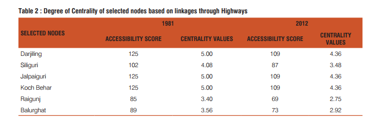
Centrality Analysis, 1981 An analysis of the centrality for the selected twenty six nodes within the state of West Bengal shows that the nodes in northern mountainous region of the state namely Darjiling Siliguri, Jalpaiguri and Koch Bihar have greater accessibility scores being connected with south Bengal by a narrow region through which only a single highway, NH 31 pass. Higher values are also observed in the western and southern most nodes in the system, like Puruliya, Asansol, Diamond Harbour and Rajpur-Sonarpur. Therefore these nodes have very high centrality values being located at the extremes of the highway network in the state. Kharagpur, though a very important railway junction, was only connected by NH 6. Thus its accessibility through roads was limited during 1981. On the other hand nodes like Siuri, Barddhaman, Durgapur, English Bazar, Chinsurah were more centrally located and was well connected by National Highways viz. NH 2, NH 34 and NH 60, thus recorded lower accessibility scores and thus degree of centrality. It is to be mentioned here that Haldia, was yet to be connected by any highway till 1981.
Centrality Analysis, 2012
Accessibility scores reduced to a minimum of forty seven for Barddhaman, which in 1981 measured sixty eight, making it the central and the most benefited node in the network with degree of centrality as 1.88 (Table 2). Its central location caused most of the highways, be it either National or State Highway, to pass through the city. Accessibility scores improved for the nodes in the northern districts, however due to their extreme locations they displayed higher centrality values. Haldia got connected by NH 41, and by the inclusion of this single highway the node measured quite a central location. Chinsurah lying on SH 6, emerged as the second most centrally located node. Siuri shifted to the third position along with English Bazar and was followed by Haora, which too was very well connected by highways. Kolkata, the capital of the state was once a centrally located node, at which most traffic originates and terminates. However, due to the expansion of the state westward, it no longer holds the central most location, neither is it very well served by highways as in the case of Barddhaman and Chinsurah.
DISCUSSION FOR DEGREE OF CENTRALITY
A proper network of National and State Highways developed during the Bombay Plan. As a result direct connectivity between nodes became significantly strong. However, State Highways were only recognized during this phase and they were yet to fully influence the transport mobility in the state. Moreover their riding quality was yet to be upgraded to the standards of a highway. Thus values of centrality in 1981 indicate an accessibility which not fully integrated. With the development of new National and State Highways to enhance the direct connections between nodes and the improvement in the riding quality of the already integrated system of highways, every node became more easily connected with one another. Accessibility scores by 2012 being much lower as compared to 1981, signify a much more developed highway linkages.
CONCLUSION
The highways in West Bengal have not only been increasing in numbers but also in their ability to carry more and more traffic. The increased connectivity through highways within the state as well as with other states, have helped in urbanization and industrialization of the state thus contributing to its development. Both NHAI and PWD are working to maintain the standards of highways in the state, but lack of integration between the organizations have often caused distress to moving traffic. Thus inspite of the connections between them, accessibility declines between them. In order to derive the benefits out of the direct connectivity and centrality measurements, therefore a cooperative approach towards upgradation of highways within the state is of necessity at present.
ACKNOWLEDGEMENT
Authors would like to express sincere gratitude to the various organizations like NHAI, PWD and Directorate of Census Operations for providing the necessary data and information for undertaking this research. Authors acknowledge the immense help received from the scholars whose articles are cited and included in references of this manuscript. Authors are also grateful to the publishers of all those articles, books and journals from where the literature for this article has been reviewed and discussed.


References:
1. Government of India. Road Development Plan for India (1981 - 2001), New Delhi: Indian Roads Congress, Ministry of Shipping and Transport (Roads Wing); 1984
2. Government of West Bengal: Statistical Abstract, West Bengal, Kolkata: Bureau of Applied Economics and Statistics; 1985
3. Government of West Bengal (1990) : District Statistical Handbook, Bureau of Applied Economics and Statistics, Kolkata.
4. Government of West Bengal (2000) : District Statistical Handbook, Bureau of Applied Economics and Statistics, Kolkata.
5. Government of West Bengal (2011) : District Statistical Handbook, Bureau of Applied Economics and Statistics, Kolkata.
6. Government of India. Investment Industry and Trade in West Bengal, Directorate of Industries, Quarterly Bulletin. December 2007 and March 2008; VI(No. 3 and 4): 58-71
7. Saxena, H.M. Transport Geography. Jaipur: Rawat Publications; 2010
8. Taaffe, Edward. J, Guathier, Howard. L. and O’ Kelly, Morton. E. Geography of Transportation. New Jersey: Prentice - Hall, Inc.; 1973
9. Garrison, W.L. Connectivity of Interstate Highway System. In : Eliot Hurst, M.E., editor. Transportation Geography. 1st ed. New York: McGraw-Hill Book Company; 1974. p. 81 – 92.
|
 IJCRR
IJCRR 


 This work is licensed under a Creative Commons Attribution-NonCommercial 4.0 International License