IJCRR - 3(10), October, 2011
Pages: 143-161
Print Article
Download XML Download PDF
PREDICTING SOIL EROSION BY WATER AND ITS MANAGEMENT IN THE LATERITIC AREAS OF
WESTERN RAMPURHAT I BLOCK (BIRBHUM, WEST BENGAL)
Author: Sandipan Ghosh, Tapas Duloi
Category: General Sciences
Abstract:Environmental geography and environmental geomorphology severally emphasize that unless loss of soil
is checked, it would amount to a great loss for mankind. Present investigation was conducted to assess the
present status of soil loss and sediment yield in the selected adjoining lateritic areas (Cainozoic upland of
laterites) of Rampurhat I block, Birbhum district (West Bengal) and Shikaripara block, Dumka district
(Jharkhand). The field study revealed that different forms of water erosion are operated there in varying
magnitude. In particular rainsplash erosion, sheet and inter-rill erosion (overland flow), rill and gully
erosion are considered here as major forms of water erosion. The soil series of Bhatina, Raspur,
Jhinjharpur and Maldiha are shallow, light-textured and gravelly with very low moisture retention
capacity, low pH and low amount of clay and organic matter. These soils (remained under barren waste
land with sparse bushy vegetation) are susceptible to moderate-severe rain-splash, rill and gully erosion,
and should be kept under thick vegetative cover and afforestation. To understand and prevent the soil
erosion at first we should make some precise quantitative estimation of soil loss. In order that, taking
small catchments and slope facets as ideal geomorphic unit, the present study is centrally focused on the
charteristics of lateritic soil, the empirical quantification of soil loss and implementation of low-cost soil
conservation measures.
Keywords: Laterites; rain-splash detachment; rill erosion; inter-rill erosion; USLE and soil conservation
Full Text:
1.0 INTRODUCTION
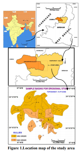
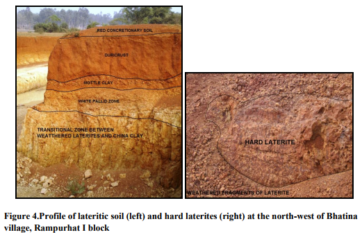
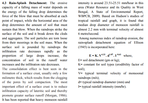
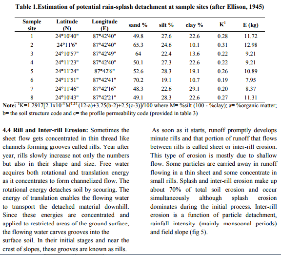
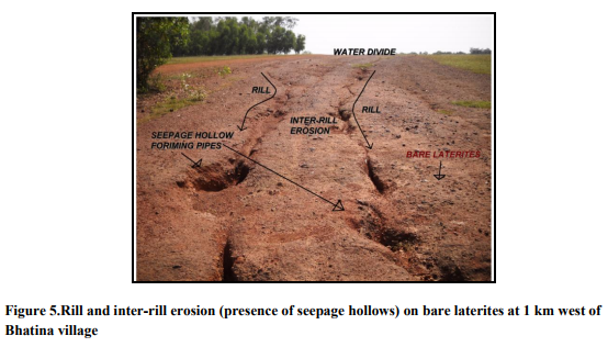
Laterisation process itself is a form of soil degradation and soil erosion by water is very much associated with the lateritic soils of West Bengal and Jharkhand. Large tracts of waste land are remained without thick forest cover and at places hard indurated laterites are exposed in the border region of Rampurhat I block, Birbhum district (West Bengal) and Shikaripara block, Dumka district (Jharkhand). Doing extensive field survey of 65.84 km2 area of study, we have found that it is worthwhile to indentify and estimate the different forms of soil erosion because a separate conservation practice is required to check each form of water erosion. It is observed that low water-holding capacity, low clay content, low percentage of organic matter, weak sub-soils structure, deforestation, grazing, peak volume of overland flow, high erosivity of monsoonal rainfall, surface crusting etc. favours rain-splash erosion, sheet erosion (inter-rill erosion), rill erosion and gully erosion.
This research article emphasizes upon firstly, the crucial features of lateritic soil which influence high erodibility of soil; secondly, on prediction of soil loss and thirdly, on suggestive low-cost conservation practices of degraded lateritic waste land and forest tracts.
2.0 OBJECTIVES
The ultimate goal is the fruitful application of pedo-geomorphic principles and quantitative techniques in the analysis of soil erosion and conservation. So to achieve this goal, the chief objectives are considered as follows:
1. Find out the important features of lateritic soil which influence soil erodibility,
2. Identify and locate the dominant forms of water erosion,
3. Quantify those forms of erosion through mathematical models,
4. Mapping the spatial variation of soil erosion, and
5. Suggest some eco-friendly low-cost conservation practices to control soil loss.
3.0 MATERIALS AND METHODS
Quantitative and process-from approaches are taken into consideration to fulfill the above objectives of this pedo-geomorphic study.
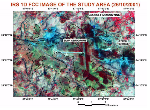
Frequent field observations, recording and interpretation are three fundamental pillars of soil erosion study. This study has both an applied aspect and environmental concern. The sub-basins and slope facets are taken as the geomorphic unit of investigation (spatial scale) and steady time scale is taken into consideration. In the pre-field session district resource map of Birbhum district (Geological Survey of India, 2001), district planning map (NATMO, 2001), topographical sheet of Survey of India (72 P/12/NE, 1979), IRS 1-D LISS III image (2001), SRTM data (2006), numerous literatures, reports, bulletins and books are collected and consulted regularly. We have taken much help of technical bulletins of National Bureau of Soil Survey (NBSS) and Land Use Planning of India. The field survey is completed with the help of Garmin G.P.S. and Abney Level. The soil samples and related geomorphic data are collected from field work. The baseline map of the study area is prepared using MapInfo 9.0 software. Raw image processing, georeferencing, sub setting of area of interest, image enhancement, and output of thematic raster and vector overlays are done in ERDAS 9.1 and ArcGis 9.2 softwares.

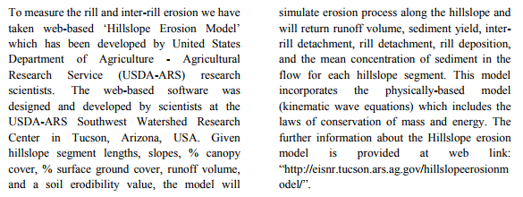
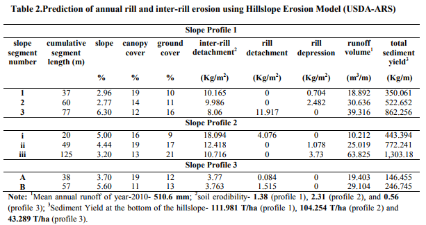
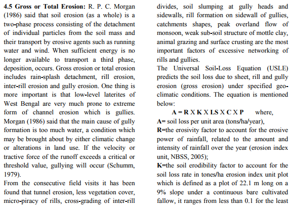
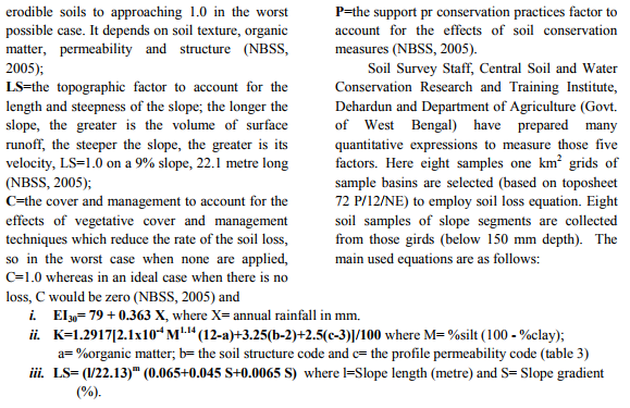


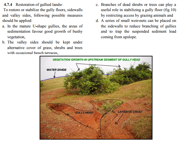
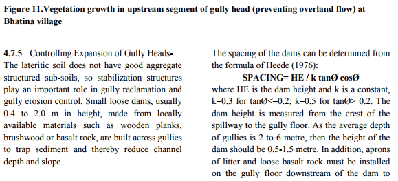


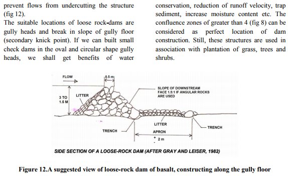
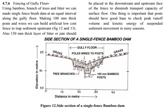
4.8 CONCLUSION
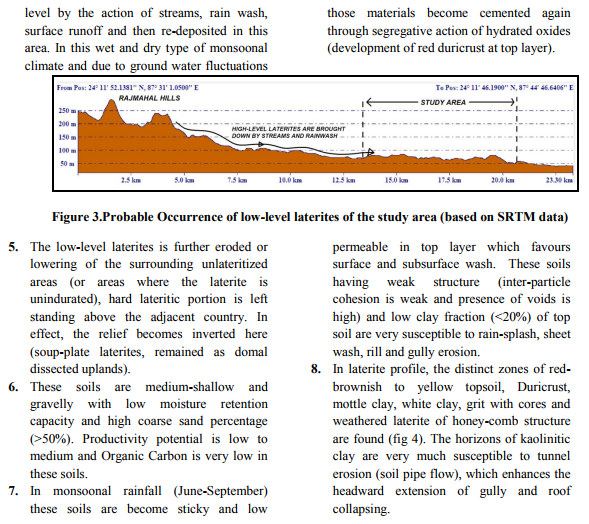
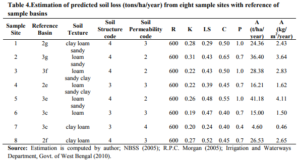
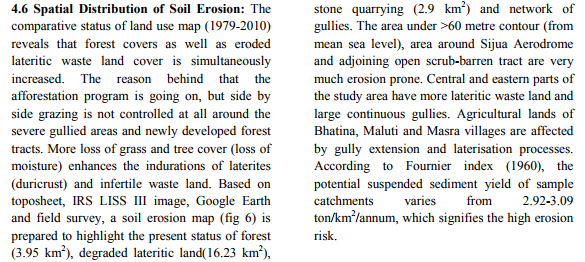
The study area is covered with Rajmahal basalt, china clay and mostly laterite. Hard massive basalt is of Jurassic to Cretaceous age, soft and medium hard laterite is of Cainozoic age and china clay is of Late Pleistocene to Early Eocene age. The region is a small portion of inter-fluvial lateritic tracts (eastern fringe of Rajmahal Hills) between Brahmani and Dawarka rivers. The region experiences a hot-dry and sub-humid climate. This geo-climatic and hydrologic condition favours the formation of low-level laterites which is also currently took place in this region. The presence of iron-oxides, hard duricrust, rich kaolinitic clay and plant fossils at different depth are the glimpses of deep chemical weathering of multi-cyclic laterites of ?Rarh Plain‘ of West Bengal. Since the morphometric and hydrological variables do not work in isolation but as closely inter-related phenomena. Some of the variables account for the major amount of explained variation of erosional landforms in this particular geo-climatic condition. These are Constant of Channel Maintenance, source points, Basin Relief, Ruggedness Number, Lemniscate Ratio, drainage texture, maximum valley-side slope and mean ground slope (based on Principal Component Analysis of thirteen variables of seventeen 3rd and 2nd order basins). From this study we can say that there will be more success in soil conservation if we give separate attention in each type of soil erosion (categorization of erosion risk areas). In brief, soil erosion ranges from 0.46-3.64 kg/m2 /year in this region. Again when we consider developing regional economy, the measures of soil conservation should be based on low-cost equipments, sustainable structures and local people participation. Therefore, to control severe soil loss and to enhance the soil loss tolerance level, we can adopt those conservation practices particularly in this lateritic area.
ACKNOWLEDGEMENT
The author expresses his great profound gratitude to the Head of Department of Geography (2009-2011), Dr. Sanat Kumar Guchhait, Reader of Post-graduate Dept. of Geography and Dr. N. C. Jana, Reader of Postgraduate Dept. of Geography, The University of Burdwan, for their encouragement, co-operation and valuable advices, commitment of time throughout the course of this work from checking, examining and compilation of information to the summing up of this article in spite of their demanding academic and administrative schedule. The author wises to express his deep sense of gratitude to senior M.Phil. scholar, Mr. Manas Nath for his patience and help during the field survey and Miss. Tithy Majhi (Part-time Lecturer, Department of Geography, Maharajadhiraj Uday Chand Women‘s College, Burdwan) for her suggestion and help during the analysis of soil samples and article writings.
References:
1. Bagchi, K.N. and Mukherjee, K.N. (1983): Diagnostic Survey of West Bengal, Calcutta University, Calcutta
2. Billi, P. and Dramis, F. (2003). Geomorphological Investigation on Gully Erosion in the Rift Valley and the Northern Highlands of Ethiopia, Catena Vol. 50, Elsevier Science
3. Blanco, H. and Lal, R. (2008). Principles of Soil Conservation and Management, Springer, Dordrecht
4. Chatterjee, A.B., Gupta, Avijit and Mukhopadhyay, P.K. (1970). West Bengal (ed.), Firma K.L. Mukhopadhyay, Calcutta
5. Chesworth, Ward (2008). Encyclopedia of Soil Science (ed.), Springer, Dordrecht
6. Chorley, Richard J. (1969). Water, Earth and Man (ed.), Methuen, London
7. Chow, V. T. (1964). Handbook of Applied Hydrology (ed.), McGraw-Hill, New York
8. Cooke, R. U. and Doornkamp, J. C. (1987). Geomorphology in Environmental Management, Clarendon Press, Oxford
9. Dury, G. H. (1976). River and River Terraces (ed.), MacMillan, London
10. Gerrard, A. J. (1981). Soils and Landforms: An Integration of Geomorphology and Pedology, George Allen and Unwin, London
11. Ghosh, S. and Maji, T. (2011). Pedogeomorphic analysis of Soil Loss in the Lateritic Region of Rampurhat I block of Birbhum district, West Bengal and Shikaripara block of Dumka district, Jharkhand, International Journal of Environmental Sciences, Volume 1, No. 7, Integrated Publishing Association
12. Hudson, Norman (1984). Soil Conservation, English Language Book Society, London
13. Jog, S. R. (1995). Indian Geomorphology, volume 1 (ed.), Rawat Publications, Jaipur
14. Knighton, David (1998). Fluvial Forms and Processes, Arnold publishers, London
15. Kumar, Anil and Pandey, R. N. (1989). Wasteland Management in India, Ashish Publishing House, New Delhi
16. McFarlane, M. J. (1976). Laterite and Landscape, Academic Press, London
17. Morgan, R. P. C. (1986). Soil Erosion and Conservation, Longman Scientific and Technical, Harlow
18. Morgan, R.P.C. and Rickson, R.J. (1995). Slope Stabilization and Erosion Control (ed.), E and FN SON publication, London
19. Panniza, Mario (1996). Environmental Geomorphology, Elsevier, Amsterdam 20. Sachetzal, R. and Anderson, S. (2005). Soils: Genesis and Geomorphology, Cambridge University Press, London
21. Sarkar, D., Nayak, D.C., Dutta, D. and Dhyani, B.L. (2005). Soil Erosion of West Bengal, National Bureau of Soil Survey and Land Use Planning, NBSS Publ. 117, Nagpur
22. Sarkar, D., Nayak, D.C., Dutta, D. and Gajbhiye, K.S. (2007). Optimizing Land Use of Birbhum District (West Bengal) Soil Resource Assessment, National Bureau of Soil Survey and Land Use Planning, NBSS Publ. 130, Nagpur
23. Singh, S., Sharma, H.S. and De, S.N (2004). Geomorphology and Environment (ed.), ACB Publications, Kolkata
24. Stallings, J. H. (1957). Soil Conservation, Prentice-Hall Publication, London
25. Wischmeir, W. H. and Smith, D.D. (1972). Predicting Rainfall-Erosion Losses from Cropland and East of the Rocky Mountains, USDA, Agriculture Handbook No. 282, Washington
26. Wischmeir, W. H. and Smith, D.D. (1978). Predicting Rainfall-Erosion Losses-A Guide to Conservation Planning, USDA, Agriculture Handbook No. 537, Washington
27. Zachar, D. (1982). Soil Erosion, Elsevier Scientific Publishing Company, Amsterdam
|




 This work is licensed under a Creative Commons Attribution-NonCommercial 4.0 International License