IJCRR - 5(4), February, 2013
Pages: 37-49
Date of Publication: 28-Feb-2013
Print Article
Download XML Download PDF
LAND RESOURCES AND PEOPLE: A STUDY IN KANKSA C.D. BLOCK, BARDDHAMAN DISTRICT, WEST BENGAL
Author: Shyamal Dutta
Category: General Sciences
Abstract:Land is an essential natural resource, both for the survival and prosperity of humanity, and for the maintenance of all terrestrial ecosystems. Over millennia, people have become progressively more aggressive in exploiting land resources for their own ends. The limits on these resources are finite while human demands on them are not. Increased demand and pressure on land resources enhance the declining crop production, increasing land degradation and competition for land in rural India. So the land utilization for various purposes plays a significant role in controlling the existing economic as well as agro-environmental system. Present study area that is Kanksa C.D. block of Barddhaman district is familiar with agriculture and forest based low level subsistence of economy, so likely land use parameters such as net sown area, forest, culturable waste and its associates such as irrigation facility etc. have been expected as controlling factors in this land use system. In this paper an attempt has been made to identify the dominant factors of agricultural system which have significant impact on development in the 30 years (1971-2001) time span mainly through Principal Component Analysis (PCA) and Geographic Information System (GIS) including the demographic aspect to correlate the land resources with people. The significant spatial mosaic based on Prinsscore shows that the existing agricultural system of this region is directly influenced by a range of variables (irrigated area, culturable waste etc.).
Keywords: Land resources, Land use, Agro-environmental System, Principal Component Analysis and GIS
Full Text:
INTRODUCTION
Land resources refer to a delineable area of the earth's terrestrial surface, encompassing all attributes of the biosphere immediately above or below this surface, including those of the nearsurface climate, the soil and terrain forms, the surface hydrology (including shallow lakes, rivers, marshes and swamps), the near-surface sedimentary layers and associated groundwater and geo-hydrological reserve, the plant and animal populations and outstandingly the human settlement pattern and activities of the past and present human activity (terracing, water storage or drainage structures, roads, buildings, etc.) (FAO/UNEP,1997). Land is not regarded simply in terms of soils and surface topography, but encompasses such features as underlying superficial deposits, climate and water resources, and also the plant and animal communities which have developed as a result of the interactions among these physical conditions. The impact of human activities, reflected by the changes in vegetative cover or by structures, is also regarded as attributes of the land. Changing one of the factors, such as land use, has potential impacts on other factors, such as flora and fauna, soils, surface water distribution and climate. Changes in these factors can readily be explained by ecosystem dynamics and the importance of their relationships in planning and management of land resources has become increasingly evident. Land is the most common denominator of all types of economic activities. It is the place where the social fabrics and agricultural practices flourish. Its use and multiple uses make it controlling factor for whatever is apparent on the surface of the earth (De and Jana, 1997). The man-land relationship can be expressed in three different facets. First, the land and the individual person who uses it; second, the man and his influence on the use of the land as a means of production. In this context institutional infrastructure should be studied for the consideration land use change. The third relationship between land and man can be expressed in terms of man as a social being and the land as an inexhaustible resource. For human existence, within certain biotic, ecological and economic conditions the utilization of land is prime importance. It involves a relationship that exist between the societies on the one hand and cultural advancement, resource planning and carrying capacity on the other (Mandal, 1990). Intensive use of land depends upon population concentration, economic prosperity through better agricultural production, human establishment, industrial location, and communication and transport while extensive use of the land is related to sparse population, dispersed settlements, absence of communication lines and the crude form of transport. However, systematic and planned utilization of land can be able to promote economic and cultural advancement. If there is no utilization of land, one cannot think of any progress. Thus the study of land utilization is of immense importance in tracing out the past use of land and its future trend. Only through the study of the past land utilization, one can able to predict its future use and evolve land use planning of a particular region. The suggestions for better use of land and the improvement of its present capability necessitate mapping and interpretation of land utilization. The changing population as well as the economic, the biological and ecological problems are so alarming that the conversation and the best utilization of land becomes necessity. OBJECTIVES OF THE PRESENT STUDY The objectives of this study can be bifurcated in different directions but the main objective can be articulated as follows: (i) To describe the distribution of present landuse pattern in Kanksa C.D. Block; (ii) To show the temporal changes in different landuse parameters (e.g., net sown area, forest cover, culturable waste etc.) in 30 years (1971-2001); (iii)To identify the controlling factors of land resources when outlook to resource development over space and time and decision making of people are the major consideration; (iv) To show the spatial mosaic of different variables controlling the land use system and (v) To provide a suitable planning for better development. Land resources and geographical background of Kanksa C.D. Block: The study area represents a small tract of westcentral Barddhaman District, comprising the Kanksa C.D. Block. This area is extended from 23°25'N to 23°40'N latitudes and 87°20'E to 87°35’E longitudes. The area is physically bounded by Ajay River in the North and Damodar River in the South. Administratively Kanksa block bounded by Birbhum District in the North, Bankura District in the South , Faridpur-Durgapur Block and Aushgram II Block of Barddhaman District in the west and east respectively (Fig.1). Total area covers of the block is 278.4 sq.km which is 3.96% of the total Barddhaman district. Total population is 151276 (Census, 2001) and population density is 543 per sq.km. In 30 years time span (1971-2001) there is a net 48.7% increase of population increase. The study area is predominantly agricultural with 47.12% of its population (Census, 2001) engaged in agriculture and allied activities and the amount of net sown area 51.2% to the total.
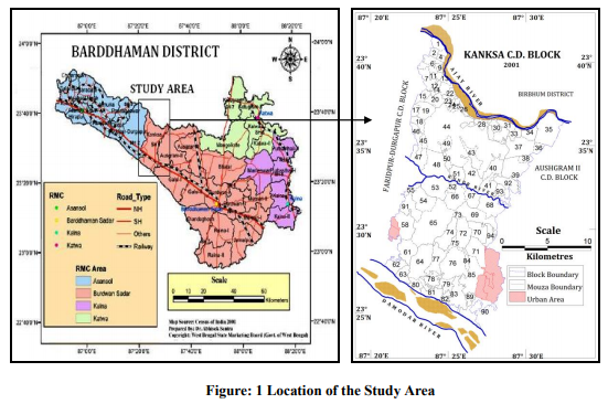
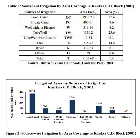
The slope of the area is towards south and southwest with very low gradient. Minimum and maximum ground elevations of the area are 51.57m and 66.74m (GSI, 2005). Close spaces contour pattern throughout area reveals that the topography is highly dissected and undulatory with valleys and ridges having rounded trough and crest repeatedly. Geologically this area is represented by Lalgarh formation, Sijua formation, Chuchura formation and Hooghly formation of Quaternary period. Lalgarh formation comprises laterite and latosol. It shows development of 0.3 to 1m thick with light grey to light brownish grey latosol comprising 71-84% sand, 14-26% silt and 1-3% clay content respectively. The soil cover developed over Sijua formation is yellowish grey in colour impregnated with caliches and belongs to silty loam to sandy loam category with 3-85% sand, 9-89% silt and 2-32% clay (GSI, 2005). Due to poor soil fertility over emphasis is given on irrigation to produce good agricultural crops for the maintenance of livelihood of local region. The main sources are surface water namely ponds, tanks and perennial rivers mainly Damodar, Ajay and Kunur. At the same time groundwater is also used as same place but the importance is relatively low (Fig. 2). Groundwater occurs in the area within a thick saturated granular zone both under unconfined and confined condition. The near surface aquifer from where unconfined groundwater is available consists of clayey silt, sandy silt and laterite. It occurs below groundwater table and tapped by dug wells (GSI, 2005)
The area under study constitutes part of two major river basins, namely Damodar and Ajay. These two drainage basins are separated by a major water divide, which runs almost parallel to G.T. Road and passes through Durgapur and Panagarh. The southern part of the area belongs to Damodar Basin where as the northern part falls in Ajay Basin. Other two important rivers are Tumuni in the north and Kunur in the middle part of the block. Landuse and its temporal change Land Use is characterized by the arrangements, activities and inputs by people to produce change or maintain a certain land cover type. (Di Gregorio and Jansen, 1998). Land use defined in this way establishes a direct link between land cover and the actions of people in their environment. The major land use classes delineated in the area included forest, net sown area, culturable waste, area not available for cultivation including residential area. Forest land cover class exclusively lies in the lateritic Lalgarh surface and constitutes about 22.41% of the study area in 2001 which is slightly decreases from areal coverage of 1971 i.e., 22.74%. The forest land comes under Durgapur P.F., Bilaspur P.F. and Ukhra P.F. It is mainly represented by dense to fairly dense mixed jungle of mainly sal trees. Locally eucalyptus plantation is also made.
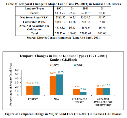
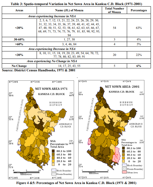
Major portion of total land area is occupied by agricultural land since these blocks have the subsistence agricultural economy which is the main occupation of the people in the block. About 49% of total are falls under the net sown area in 2001 which is increased from46.25% in 1971. Changing physico-cultural settings over the years is responsible for significant spatiotemporal variation in net sown area of this study area. The proportion of net sown area in this block increased from 47.7% (13286.36 hec.) in 1971 to 51.2% (13634.2 hec.) in 2001, amounting 3.5% increase of land in this category. Over 30 years of time span there is a net increase of 347.84 hec of net sown area in the study area. From geographical perspective change in net sown area (1971-2001), of this study area may be divided into three broad regions (Table: 3 and Fig. 4 and 5). This change is mainly due to irrigation development in the study area during the period between 1971 to 2001. In this period about 3048.29 hec area under irrigation is increased that is 11.37 % to total area. So within these 30 years irrigation plays an important role in the agricultural expansion and this is also reflected in the wasteland reclamation. About 7% of culturable wasteland has been reclaimed within this period (Fig. 3). Area not available for cultivation is increased about 1 % because urban expansion mainly in Kanksa (CT), Debipur (CT) and Proyagpur (CT) around Panagarh region.
SYSTEM ANALYSIS OF LANDUSE THROUGH PCA:
From the above geo-environmental analysis along with land uses in Kanksa block it is clear that the whole region is based on subsistence level of agricultural economy where inbuilt natural resources and their uses have great influence of prevailing economy. Though some parts of the area is uplifted as urban expansion but main strength of economy is the agricultural production and forest-based production mainly in upper portion of the study area. So, land resources and different land use practices are the controlling factor for livelihood. In this agricultural system rugged topography, laterite soil, climate, groundwater situation exert hindrance in the proliferation of crop production through agricultural production have been expanded at a significant level in between 1971- 2001. So two judge the controlling factors of this agricultural increase during the span of 30 years period (1971-2001) land use based parameters are very much essential to examine. Irrigation facility plays a significant role during this period. In this situation a multivariate analysis to evaluate the whole system controlled by different variables is relevant in this regard. Principal component analysis (Hotelling, 1933) may be the suitable techniques to this evaluation because this technique synthesizes a large number of variables into a smaller number of general components, which retain the maximum amount of descriptive ability (Mahmood and Raza, 2002).
SELECTION OF VARIABLES
To assess the change of agro-economic system in spatio-temporal context, different land uses and social factors are taken as the variables for principal component analysis. In this context some other social parameter could have been included but here we have considered those parameters which are directly related to agrarian land use system. Data of major land use parameters and demographic aspects are collected from District Census Handbook of Barddhaman District in 1971 and 2001.These are as follows: V1= Population density V2= Percentages of S.T. population to total population V3=Percentages of forest cover to total area V4=Percentages of unirrigated area to total area V5= Percentages of culturable waste to total area V6=Percentages of area not available for cultivation to total area V7= Percentages of irrigated area to total area Population density is an important aspect to assess the pressure of population on existing land area. It is also very crucial to examine the level of development in any part of land because all development in earth surface can be judged in terms of human development. Percentages of scheduled tribe population are an indicator of backwardness. In this forest based ecosystem high concentration is seen mainly in the upper and central part of the study area. Forest resources are major sources of their earnings. Four major land use parameters are chosen in this case. Forest cover is predominant in this block. About 22.41% (2001) of total area is covered by mainly under Ukhra, Durgapur and Bilaspur forest ranges. Area under agricultural practices i.e., net sown area have a high level significance in this area. About 48.97% (2001) area falls under this category. Mainly Irrigation development over 30 years (1971-2001) is undoubtedly the controlling factor to such level of agricultural expansion. Irrigation parameters are selected because it enhances the potentiality of agricultural field to uplift it from mono crop production to multi crop production. Naturally high level of unirrigated area put hindrance to such development. Culturable wasteland is also an important indicator of backwardness as it comprises the used and fallow land. Major part in the study area has been fallen under this category due to laterite gully affected areas, rugged topography etc. Area not available for cultivation has been considered mainly as a positive factor for development because it comprises mainly the build up area and urban areas. After calculating Principal Component loadings upto three stages Prinsscore have been calculated based on first principal component of each variable. The following formula has been adopted in this purpose: Prinsscore (Pi) = {(V1×v1) + (V2×v2) + (V3×v3 ) + (V4×v4 ) +..........+(Vn ×vn )}÷Initial Eigen Value. Where, V1, V2, ......Vn= actual values of variables upto ‘n’ number v1, v2, ........vn = loadings from first principal component of each variables(eigen Vectors)
REFLECTION FROM PCA:
First stage analysis of the data based on 1971 has been progressed in two stages considering irrigation as a variable and omitting irrigation as a variable because during this period irrigation facility was low.
a. PCA in 1971 with Irrigation as a variable
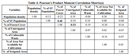
In the first stage irrigation facility has been considered as a controlling factor. Now principal component analysis has been done upto three stage. All the variables are very slightly (positive and negative) correlated to each other expect irrigated area. In first principal component analysis only 29.54% variance is explained (Table: 5). In this stage unirrigated area (0.71) and forest cover (-0.83) become the controlling factors positively and negatively respectively. With the 47.59% of explained variations in the second PCA, area not available for cultivation (0.71) becomes the guiding factor of whole system (Table: 5). In the last stage of analysis with an explanation of 62.86%, culturable waste becomes the controlling factor. So there is mixed influence of different variables in the year of 1971.

b. PCA in 1971 without Irrigation Parameter
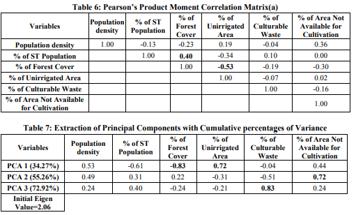
Within a span the 30years (1971-2001) irrigation facility has developed a lot which has significant role in the agricultural development of the study area. But is there any influence of irrigation in the year of 1971 to control the agricultural system of this area. To get a better response irrigated area has been excluded now for 1971 database. Results are more or less same. Again forest cover, unirrigated area i.e., absence of irrigation and culturable wasteland plays the controlling role in three stages of PCA (Table: 7)
c. PCA in 2001
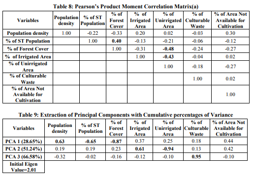
In 2001 high level expansion of agricultural land and massive change in irrigation facility have occurred with the simultaneous growth of urban landuse due to proximity to Durgapur urban area. Beside this wasteland reclamation has also taken place. As a result this whole system becomes more complex. Degree of correlation increased in this time span (Table: 8). From first PCA with an explained variation of 28.65%, population density (0.63) and forest cover (- 0.87) become the controlling factors (Table: 9). Here it is clear that deforestation and increased demand of population influences on agricultural expansion. Irrigated area (0.61) and unirrigated area (-0.94) also become crucial in the second stage of PCA which clearly shown the positive affect of irrigation on agricultural development to a considerable extent. In third stage of PCA culturable waste (0.95) has high level significance because huge amount of wasteland has been reclaimed through irrigation practices for agricultural development within the time span of 30 years (Table: 9).
SPATIAL DIMENSION
Spatial dimension of agro-economic system can be perceived by prin-score values (Fig. 6 and 7). Mouzas having predominant forest cover (e.g., Bistupur-J.L. No. 44, Brahamangram-J.L. No. 38, Paschimgangarampur- J.L. No. 92, Sadhumara-J.L. No. 73 etc.), concentration of tribal population and lack of irrigation facility response negatively in both stages (analysis with and without considering the irrigation parameter). Mouza having high level of irrigation facility and culturable wasteland with high population pressure (Kanksa, Debipur, Proyagpur, Basuda etc.) have a better positive response in the first stage of analysis.
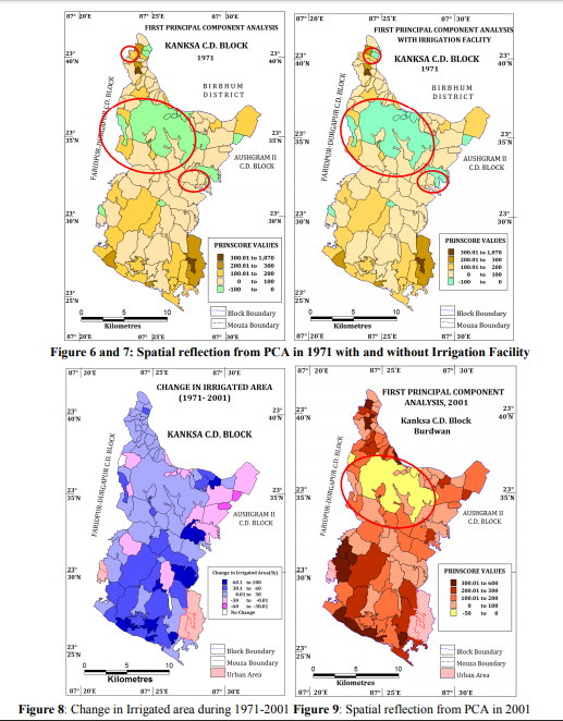
During 30 years of time span high level increase in irrigated area (Fig. 8), agricultural scenario has also change massively. This affect may reflect in the last part of PCA analysis. Here areas having high amount of irrigated area and low amount of culturable waste or both have high positive response (Fig. 9). But area under predominant forest cover (e.g., Bistupur-J.L. No. 44) responses negatively and indicate very low level of development in agriculture as well as society.
CONCLUSION
Basically different land uses and also some population parameters are the main controller of present agro-environmental system where irrigated area plays a significant role in the agricultural development. Areas having no or minimum irrigation facility and predominant forest cover added with tribal population response negatively which indicates high level backwardness. Greater attention should pay on these regions mainly in the rugged lateritic region of upper part of the study area to uplift this in to mainstream economy. Beside this, over exploitation of groundwater for irrigation purposes, canal irrigation, deforestation are the main negative outcome of this agricultural development though those have trigger agricultural development, but in long those will add environmental problems. So, search for alternative avenues have great importance in present day for future sustainability. Over 30 years of time span the study area has experienced a wide range of change in net sown area. In terms of actual areal coverage only 347.84 hectares under NSA is extended to agricultural land use. But there is enough provision for further extension of cultivation in the study area mainly in terms of wasteland reclamation. Because 54% mouzas have experienced increase in net sown area only upto 30% and at present about 7.82% of total land in the study area belongs to cultivable wasteland. Development of wasteland requires a package of treatment which includes soil erosion control measures, erection of ground water recharge structure and suitable crop production system (Prasad and Ghosh, 2011). Soil erosion control measures are very much essential because huge amount of fertile top soil have been eroded away every year through rill and gully erosion mainly in the forest-endowed upper part of the study area. To decrease sole dependency on ground water as a source of irrigation, use of surface water bodies may be effective. People should be aware about if that extraction of ground water is environmentally hazardous and stagnant surface water has wider scope of small scale irrigation, which may serve wider area if proper reclamation of ponds and wetlands is taken. Rain water harvesting in terms of dug well, tank and ponds are essential tools to mitigate this problem. To promote sustainable agriculture various methods should be applied. These are polycultures in terms of fallow rotation, use of residues, rotation with legumes, bio-manuring, alley cropping, contour planting, etc (Santra, 2010). Social forestry programmes may be effective in this context, because it may increase the green cover in fallow land as well as in culturable wasteland so that already deforested area can be used for agricultural purposes. Besides this social forestry programmes may bring alternative sources of fuel, timber and more specifically income, from different forest products helpful for poor tribals so that pressure on agricultural land decreases and environment may achieve its sustainable level.
ACKNOWLEDGEMENT
The authors expressed his great profound gratitude to Dr. Sanat Kumar Guchhait, Associate Professor of Postgraduate Dept. of Geography, The University of Burdwan (West Bengal), for his encouragement, cooperation and valuable advices, commitment of time throughout the course of this work from checking, examining and compilation of information to the summing up of this article.
References:
1. Bhattacharya, A.K and N. Dhar, Geological survey of India, (2005) “A Report on GeoEnvironmental Appraisal in DurgapurPanagarh Urban Area and Its Environs for developmental Activities within AsansolDurgapur Development Authority Area, District Barddhaman, W.B.”, Eastern Region, Kolkata
2. De, N.K. and Jana, N.C. (1997): The Land: Multifaceted Appraisal and Management, Sribhumi Publishing Co., Calcutta, pp. 6-7
3. Di Gregorio, A. and Jansen, L.J.M. 1998. A New Concept for A Land Cover Classification System. The Land 2(1): 55- 65.
4. District Census Handbook of Barddhaman District (1971 and 2001), Govt. of India
5. FAO/UNEP. 1997. Negotiating a Sustainable Future for Land. Structural and Institutional Guidelines for Land Resources Management in the 21st Century. FAO/ UNEP, Rome.
6. Hotelling, H. (1933) Analysis of a complex statistical variables into Principal Component, Journal of Educational Psychology, vol.24, pp. 407-441
7. Mahmood, A. and Raza, M. (2002) Statistical Methods in Geographical Studies, Rajesh Publications, New Delhi, p. 159
8. Mandal, R.B., (1990) Land Utilization: Theory and Practice, Concept Publishing Company, New Delhi, pp.4-5
9. Prasad, N. and Ghosh, T. (2011). Spatiotemporal Variation in Net Sown Area in Southwest Birbhum District, West Bengal, Practising Geographer: A Journal of Indian Geographical Foundation, 15 (winter):2, 56- 67
10. Santra, S.C. (2010), Environmental Science. New Central Book Agency (P) Ltd., Delhi.p.526
|




 This work is licensed under a Creative Commons Attribution-NonCommercial 4.0 International License